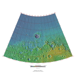
Ismenius Lacus quadrangle
The Ismenius Lacus quadrangle is one of a series of 30 quadrangle maps of Mars used by the United States Geological Survey (USGS) Astrogeology Research Program . The quadrangle is located in the northwestern portion of Mars’ eastern hemisphere and covers 0° to 60° east longitude (300° to 360° west longitude) and 30° to 65° north latitude. The quadrangle uses a Lambert conformal conic projection at a nominal scale of 1:5,000,000 (1:5M). The Ismenius Lacus quadrangle is also referred to as MC-5 (Mars Chart-5). [1] The southern and northern borders of the Ismenius Lacus quadrangle are approximately 3,065 km (1,905 mi) and 1,500 km (930 mi) wide, respectively. The north-to-south distance is about 2,050 km (1,270 mi) (slightly less than the length of Greenland). [2] The quadrangle covers an approximate area of 4.9 million square km, or a little over 3% of Mars’ surface area. [3] The Ismenius Lacus quadrangle contains parts of Acidalia Planitia , Arabia Terra , Vastitas Borealis , and Terra Sabaea . [4]
Page Revisions
| Year | Metadata | Sections | Top Words | First Paragraph |
| 2018 |
448898 characters 28 sections 338 paragraphs 317 images 302 internal links 98 external links |
8. Climate change caused ice-rich features 12. Mesas formed by ground collapse 15. Polygonal patterned ground |
hiwish 0.616 hirise 0.439 program 0.329 view 0.182 brain 0.175 terrain 0.136 dipping 0.113 ice 0.111 ismenius 0.108 lacus 0.093 glacier 0.088 lyot 0.084 close 0.080 mold 0.077 image 0.074 |
The Ismenius Lacus quadrangle is one of a series of 30 quadrangle maps of Mars used by the United States Geological Survey (USGS) Astrogeology Research Program . The quadrangle is located in the northwestern portion of Mars’ eastern hemisphere and covers 0° to 60° east longitude (300° to 360° west longitude) and 30° to 65° north latitude. The quadrangle uses a Lambert conformal conic projection at a nominal scale of 1:5,000,000 (1:5M). The Ismenius Lacus quadrangle is also referred to as MC-5 (Mars Chart-5). [1] The southern and northern borders of the Ismenius Lacus quadrangle are approximately 3,065 km (1,905 mi) and 1,500 km (930 mi) wide, respectively. The north-to-south distance is about 2,050 km (1,270 mi) (slightly less than the length of Greenland). [2] The quadrangle covers an approximate area of 4.9 million square km, or a little over 3% of Mars’ surface area. [3] The Ismenius Lacus quadrangle contains parts of Acidalia Planitia , Arabia Terra , Vastitas Borealis , and Terra Sabaea . [4] |
| 2017 |
415052 characters 26 sections 306 paragraphs 286 images 300 internal links 84 external links |
8. Climate change caused ice-rich features 12. Mesas formed by ground collapse 15. Polygonal patterned ground |
hiwish 0.598 hirise 0.431 program 0.320 brain 0.187 view 0.186 terrain 0.142 ismenius 0.118 ice 0.115 dipping 0.113 lacus 0.102 glacier 0.096 lyot 0.092 mold 0.084 close 0.082 image 0.078 |
The Ismenius Lacus quadrangle is one of a series of 30 quadrangle maps of Mars used by the United States Geological Survey (USGS) Astrogeology Research Program . The quadrangle is located in the northwestern portion of Mars’ eastern hemisphere and covers 0° to 60° east longitude (300° to 360° west longitude) and 30° to 65° north latitude. The quadrangle uses a Lambert conformal conic projection at a nominal scale of 1:5,000,000 (1:5M). The Ismenius Lacus quadrangle is also referred to as MC-5 (Mars Chart-5). [1] The southern and northern borders of the Ismenius Lacus quadrangle are approximately 3,065 km (1,905 mi) and 1,500 km (930 mi) wide, respectively. The north-to-south distance is about 2,050 km (1,270 mi) (slightly less than the length of Greenland). [2] The quadrangle covers an approximate area of 4.9 million square km, or a little over 3% of Mars’ surface area. [3] The Ismenius Lacus quadrangle contains parts of Acidalia Planitia , Arabia Terra , Vastitas Borealis , and Terra Sabaea . [4] |
| 2016 |
322700 characters 23 sections 245 paragraphs 231 images 289 internal links 29 external links |
7. Climate change caused ice-rich features 11. Mesas formed by ground collapse 13. Polygonal patterned ground |
hiwish 0.573 hirise 0.424 program 0.308 brain 0.211 terrain 0.166 view 0.159 ismenius 0.141 dipping 0.140 lacus 0.122 ice 0.110 lyot 0.106 glacier 0.091 ribbed 0.089 image 0.086 mensae 0.084 |
The Ismenius Lacus quadrangle is one of a series of 30 quadrangle maps of Mars used by the United States Geological Survey (USGS) Astrogeology Research Program . The quadrangle is located in the northwestern portion of Mars’ eastern hemisphere and covers 0° to 60° east longitude (300° to 360° west longitude) and 30° to 65° north latitude. The quadrangle uses a Lambert conformal conic projection at a nominal scale of 1:5,000,000 (1:5M). The Ismenius Lacus quadrangle is also referred to as MC-5 (Mars Chart-5). [1] The southern and northern borders of the Ismenius Lacus quadrangle are approximately 3,065 km (1,905 mi) and 1,500 km (930 mi) wide, respectively. The north-to-south distance is about 2,050 km (1,270 mi) (slightly less than the length of Greenland). [2] The quadrangle covers an approximate area of 4.9 million square km, or a little over 3% of Mars’ surface area. [3] The Ismenius Lacus quadrangle contains parts of Acidalia Planitia , Arabia Terra , Vastitas Borealis , and Terra Sabaea . [4] |
| 2015 |
187796 characters 15 sections 110 paragraphs 99 images 252 internal links 22 external links |
7. Climate change caused ice-rich features |
hiwish 0.329 hirise 0.307 ismenius 0.281 lacus 0.244 program 0.185 ice 0.179 mensae 0.170 lyot 0.163 ctx 0.154 glacier 0.144 terrain 0.138 cracks 0.137 ribbed 0.127 deuteronilus 0.127 brain 0.125 |
The Ismenius Lacus quadrangle is one of a series of 30 quadrangle maps of Mars used by the United States Geological Survey (USGS) Astrogeology Research Program . The quadrangle is located in the northwestern portion of Mars’ eastern hemisphere and covers 0° to 60° east longitude (300° to 360° west longitude) and 30° to 65° north latitude. The quadrangle uses a Lambert conformal conic projection at a nominal scale of 1:5,000,000 (1:5M). The Ismenius Lacus quadrangle is also referred to as MC-5 (Mars Chart-5). [1] The southern and northern borders of the Ismenius Lacus quadrangle are approximately 3,065 km (1,905 mi) and 1,500 km (930 mi) wide, respectively. The north to south distance is about 2,050 km (1,270 mi) (slightly less than the length of Greenland). [2] The quadrangle covers an approximate area of 4.9 million square km, or a little over 3% of Mars’ surface area. [3] The Ismenius Lacus quadrangle contains parts of Acidalia Planitia , Arabia Terra , Vastitas Borealis , and Terra Sabaea . [4] |
| 2014 |
134627 characters 12 sections 57 paragraphs 52 images 243 internal links 18 external links |
7. Climate change caused ice-rich features |
ismenius 0.344 lacus 0.299 hirise 0.266 lyot 0.263 mensae 0.256 hiwish 0.214 deuteronilus 0.184 glacier 0.183 ice 0.165 fretted 0.151 pits 0.139 program 0.131 glaciers 0.121 protonilus 0.111 image 0.108 |
The Ismenius Lacus quadrangle is one of a series of 30 quadrangle maps of Mars used by the United States Geological Survey (USGS) Astrogeology Research Program . The quadrangle is located in the northwestern portion of Mars’ eastern hemisphere and covers 0° to 60° east longitude (300° to 360° west longitude) and 30° to 65° north latitude. The quadrangle uses a Lambert conformal conic projection at a nominal scale of 1:5,000,000 (1:5M). The Ismenius Lacus quadrangle is also referred to as MC-5 (Mars Chart-5). [1] The southern and northern borders of the Ismenius Lacus quadrangle are approximately 3,065 km (1,905 mi) and 1,500 km (930 mi) wide, respectively. The north to south distance is about 2,050 km (1,270 mi) (slightly less than the length of Greenland). [2] The quadrangle covers an approximate area of 4.9 million square km, or a little over 3% of Mars’ surface area. [3] |
| 2013 |
134539 characters 12 sections 58 paragraphs 52 images 243 internal links 18 external links |
7. Climate change caused ice-rich features |
ismenius 0.344 lacus 0.299 hirise 0.266 lyot 0.263 mensae 0.256 hiwish 0.214 deuteronilus 0.184 glacier 0.183 ice 0.165 fretted 0.151 pits 0.139 program 0.131 glaciers 0.121 protonilus 0.111 image 0.108 |
The Ismenius Lacus quadrangle is one of a series of 30 quadrangle maps of Mars used by the United States Geological Survey (USGS) Astrogeology Research Program . The quadrangle is located in the northwestern portion of Mars’ eastern hemisphere and covers 0° to 60° east longitude (300° to 360° west longitude) and 30° to 65° north latitude. The quadrangle uses a Lambert conformal conic projection at a nominal scale of 1:5,000,000 (1:5M). The Ismenius Lacus quadrangle is also referred to as MC-5 (Mars Chart-5). [1] The southern and northern borders of the Ismenius Lacus quadrangle are approximately 3,065 km (1,905 mi) and 1,500 km (930 mi) wide, respectively. The north to south distance is about 2,050 km (1,270 mi) (slightly less than the length of Greenland). [2] The quadrangle covers an approximate area of 4.9 million square km, or a little over 3% of Mars’ surface area. [3] |
| 2012 |
125047 characters 11 sections 56 paragraphs 49 images 242 internal links 18 external links |
ismenius 0.343 lacus 0.297 lyot 0.277 hirise 0.272 mensae 0.269 hiwish 0.214 deuteronilus 0.194 glacier 0.175 fretted 0.158 pits 0.146 program 0.132 glaciers 0.127 protonilus 0.116 image 0.113 mamers 0.111 |
The Ismenius Lacus quadrangle is one of a series of 30 quadrangle maps of Mars used by the United States Geological Survey (USGS) Astrogeology Research Program . The quadrangle is located in the northwestern portion of Mars’ eastern hemisphere and covers 0° to 60° east longitude (300° to 360° west longitude) and 30° to 65° north latitude. The quadrangle uses a Lambert conformal conic projection at a nominal scale of 1:5,000,000 (1:5M). The Ismenius Lacus quadrangle is also referred to as MC-5 (Mars Chart-5). [1] |
|
| 2011 |
70673 characters 11 sections 50 paragraphs 38 images 100 internal links 13 external links |
ismenius 0.353 lacus 0.306 mensae 0.272 lyot 0.272 hirise 0.245 deuteronilus 0.188 hiwish 0.155 glacier 0.152 fretted 0.148 pits 0.143 glaciers 0.139 protonilus 0.127 image 0.123 mamers 0.121 kettles 0.113 |
The Ismenius Lacus quadrangle is one of a series of 30 quadrangle maps of Mars used by the United States Geological Survey (USGS) Astrogeology Research Program . The quadrangle is located in the northwestern portion of Mars’ eastern hemisphere and covers 0° to 60° east longitude (300° to 360° west longitude) and 30° to 65° north latitude. The quadrangle uses a Lambert conformal conic projection at a nominal scale of 1:5,000,000 (1:5M). The Ismenius Lacus quadrangle is also referred to as MC-5 (Mars Chart-5). [1] |
|
| 2010 |
62190 characters 11 sections 45 paragraphs 33 images 97 internal links 12 external links |
ismenius 0.368 lacus 0.319 mensae 0.283 lyot 0.283 hirise 0.221 deuteronilus 0.196 glacier 0.159 fretted 0.154 protonilus 0.132 glaciers 0.128 image 0.128 mamers 0.126 kettles 0.117 ice 0.117 pits 0.116 |
The Ismenius Lacus quadrangle is one of a series of 30 quadrangle maps of Mars used by the United States Geological Survey (USGS) Astrogeology Research Program . The quadrangle is located in the northwestern portion of Mars’ eastern hemisphere and covers 0° to 60° east longitude (300° to 360° west longitude) and 30° to 65° north latitude. The quadrangle uses a Lambert conformal conic projection at a nominal scale of 1:5,000,000 (1:5M). The Ismenius Lacus quadrangle is also referred to as MC-5 (Mars Chart-5). [1] |
|
| 2009 |
44439 characters 9 sections 31 paragraphs 21 images 94 internal links 8 external links |
ismenius 0.364 lacus 0.316 lyot 0.309 fretted 0.216 mamers 0.177 hirise 0.173 kettles 0.165 cerulli 0.154 deltas 0.137 coloe 0.126 aprons 0.115 ice 0.113 glaciers 0.113 cliffs 0.108 ridges 0.098 |
The Ismenius Lacus quadrangle is one of a series of 30 quadrangle maps of Mars used by the United States Geological Survey (USGS) Astrogeology Research Program . The quadrangle is located in the northwestern portion of Mars’ eastern hemisphere and covers 0° to 60° east longitude (300° to 360° west longitude) and 30° to 65° north latitude. The quadrangle uses a Lambert conformal conic projection at a nominal scale of 1:5,000,000 (1:5M). The Ismenius Lacus quadrangle is also referred to as MC-5 (Mars Chart-5). [1] |